Doi Inthanon
ดอยอินทนนท์ · Chiang Mai Province
Best Season
November to February (cool, clear, best birding)
Score
7.5 / 10
Elevation
2,565 m
Area
482 km²
About Doi Inthanon
Doi Inthanon is the crown of Thailand, literally the country's highest point at 2,565 meters. The national park spans an extraordinary range of ecosystems from lowland dipterocarp forest through cloud forest to a unique sphagnum bog at the summit. The mountain is a magnet for birdwatchers with nearly 400 species recorded and offers some of the most dramatic waterfalls in northern Thailand.
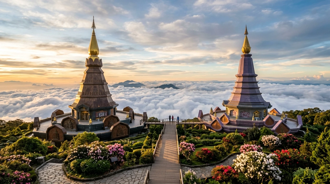
Two ornate twin chedis near the summit, built for the King and Queen, provide the park's most photographed viewpoint. The Kew Mae Pan nature trail offers a stunning 3 km ridge walk with panoramic views when it is open (November to May). Wachirathan waterfall is a powerful 80-meter cascade, while Mae Ya waterfall is considered one of Thailand's most beautiful.
The surrounding area is home to Karen and Hmong communities who maintain traditional agriculture including Thailand's highest coffee plantations. The Royal Agricultural Station Inthanon showcases highland farming. Most visitors day-trip from Chiang Mai, 90 minutes away, though camping and park bungalows are available. The summit can drop to near freezing on cold December and January mornings.
Historical Note
The park was established in 1972 and named after the last king of Chiang Mai, Inthawichayanon, who cared deeply about the forests. The area is home to Karen and Hmong hill-tribe communities with long histories of highland agriculture.
Best time to visit: November to February (cool, clear, best birding)
At a Glance
Thai Name
ดอยอินทนนท์
Province
Chiang Mai
Region
Northern
Area
482 km²
Elevation
2,565 m
Costs
Typical prices you'll encounter when visiting Doi Inthanon. Grouped by category.
entertainment
| Item | Low (THB) | High (THB) |
|---|---|---|
| Park entrance (foreigner) | 300 | 300 |
| Guided birding tour (full day) | 2,000 | 5,000 |
| Kew Mae Pan trail guide | 100 | 100 |
accommodation
| Item | Low (THB) | High (THB) |
|---|---|---|
| Park campsite (per person) | 30 | 30 |
| Park bungalow | 600 | 2,400 |
| Guesthouse (Chom Thong) | 300 | 700 |
| Resort near park | 1,500 | 5,000 |
| Hill-tribe homestay | 500 | 1,000 |
food
| Item | Low (THB) | High (THB) |
|---|---|---|
| Meal at park restaurant | 60 | 150 |
| Meal in Chom Thong | 40 | 80 |
| Coffee at Royal Project | 50 | 100 |
transport
| Item | Low (THB) | High (THB) |
|---|---|---|
| Songthaew to summit | 200 | 300 |
| Organized tour from Chiang Mai | 800 | 2,000 |
| Motorbike rental (day) | 200 | 350 |
utilities
| Item | Low (THB) | High (THB) |
|---|---|---|
| Tent rental at campsite | 150 | 225 |
Weather & Climate
November to February for cool clear weather, best birding, and possible frost at the summit. March to May brings burning season haze. June to October has spectacular waterfalls but leeches and some trail closures.
Burning Season Warning
March to May: haze from agricultural burning severely reduces visibility. Avoid for views.
| Month | High °C | Low °C | Rain (mm) | Humidity |
|---|---|---|---|---|
| Jan | 12 | 2 | 5 | 60% |
| Feb | 15 | 4 | 5 | 55% |
| Mar | 19 | 8 | 15 | 50% |
| Apr | 21 | 11 | 50 | 58% |
| May | 20 | 13 | 180 | 78% |
| Jun | 19 | 14 | 160 | 82% |
| Jul | 18 | 14 | 200 | 85% |
| Aug | 18 | 14 | 230 | 88% |
| Sep | 18 | 13 | 250 | 88% |
| Oct | 17 | 10 | 120 | 80% |
| Nov | 15 | 6 | 30 | 65% |
| Dec | 12 | 2 | 10 | 60% |
Things to Do
Twin Chedis (Naphamethinidon & Naphaphonphumisiri)
พระมหาธาตุนภเมทนีดล
Ornate twin pagodas built for King and Queen near the summit, offering stunning panoramic views on clear days.
Kew Mae Pan Nature Trail
เส้นทางกิ่วแม่ปาน
Stunning 3 km ridge walk with panoramic views through cloud forest. Guide required. Opens November to May.
Wachirathan Waterfall
น้ำตกวชิรธาร
Powerful 80-meter cascade accessible by a short walk. The mist spray is refreshing on hot days.
Ang Ka Nature Trail (Summit Boardwalk)
อ่างกา
360-meter boardwalk through sphagnum moss cloud forest at the summit. An otherworldly landscape.
Birdwatching at Km 31
Thailand's premier birding spot with 382 species recorded. The Km 31 checkpoint area is famous for mixed flocks.
Mae Ya Waterfall
น้ำตกแม่ยะ
Considered one of Thailand's most beautiful waterfalls, 250 meters tall. Accessed via a separate road from Chom Thong.
Karen and Hmong Villages
Traditional hill-tribe communities with weaving, rice terraces, coffee cultivation, and flower farms.

Food Nearby
กาแฟดอยอินทนนท์
Hill Tribe Coffee
Arabica grown above 1,200 meters, excellent quality from Royal Project farms. Some of Thailand's best coffee.
50-100
Royal Agricultural Station and park coffee shops
ข้าวซอย
Khao Soi
Northern Thai curry noodle soup available in Chom Thong, the nearest town.
35-55
Chom Thong noodle shops
สตรอว์เบอร์รี่
Fresh Strawberries
Grown at high elevation on the mountain. Available December to February during harvest season.
40-80 per punnet
Roadside stalls along the park road
ไส้อั่ว
Sai Oua (Northern Sausage)
Herb-packed northern Thai sausage available at Chom Thong morning market.
30-50
Chom Thong morning market
Night Markets
- Chom Thong morning market
Where to Stay
Hostel Dorm
200 - 400
THB / night
Budget Hotel
300 - 700
THB / night
Mid-Range
1,000 - 3,000
THB / night
Luxury
3,000 - 5,000
THB / night
Best Areas to Base Yourself
Booking Tip
Park bungalows book via nps.dnp.go.th and are popular on weekends. Most visitors day-trip from Chiang Mai. For overnight stays, lodges along Route 1009 near the park gate are convenient.

Getting There from Bangkok
Flight to Chiang Mai + drive
1.5 hours flight + 1.5 hours
1,500-4,000 + fuel THB
Overnight train to Chiang Mai + drive
12 hours + 1.5 hours
500-1,200 + fuel THB
Organized tour from Chiang Mai
Full day
800-2,000 THB
Festivals & Events
Cool Season Peak
Thai visitors flock for cold weather and possible frost at the summit. Very crowded on weekends.
Cherry Blossom Season
Wild Himalayan cherry (Nang Phaya Sua Khrong) blooms with beautiful pink canopy in the mid-zone.
Wildflower Season
Terrestrial orchids and other highland flowers bloom across the upper zones during the rainy season.
Practical Info
Hospital
Chom Thong Hospital
Best SIM Provider
AIS
ATM Availability
Limited
Language Tip
Thai at lower elevations. Karen and Hmong in villages. Very little English. Park rangers may speak some English.
Drinking Water
Bring bottled water. Limited availability inside the park.
Tipping Culture
200-500 THB for birding guides is generous by local standards
7-Eleven Density
Sparse
Emergency Numbers
Tourist police 1155, Emergency 191
Nearby Attractions
Frequently Asked Questions
Can I visit Doi Inthanon as a day trip from Chiang Mai?
Yes, this is the most common way. Leave early (6-7 AM) to catch sunrise mist. Most organized tours follow this route.
How cold does it actually get?
Summit can hit 0-5 degrees Celsius on the coldest December and January mornings. Mid-mountain is 10-20 degrees in winter. Bring a proper jacket and warm layers.
Is the summit viewpoint worth it?
The summit itself is just a small stele in dense forest. The twin chedis 7 km below have the actual views. Do not skip them.
Do I need a guide?
Only required for Kew Mae Pan trail. Other trails and waterfalls are self-guided. For birding, a specialized guide is highly recommended.
Can I see the sea of mist?
Yes, from Kew Mae Pan trail and the twin chedis viewpoint on clear November to February mornings. Arrive before 7 AM.
Is it accessible by public transport?
Difficult. You can bus to Chom Thong from Chiang Mai then find a songthaew up the mountain, but service is unreliable. A tour or rental vehicle is strongly recommended.